Archive for January, 2009

white and blues

January 31, 2009

 another uk  loss today billy G may be getting close to the hot seat in my view 4th place in the sec east in one of the worst confrences if tenn wins tonight. it’s not all his  fault the team has little mental toughness and guts and this shows in the lack of rebounds.  that takes care of the blue blues.

1. now on to the white blues are monday tuesday looks as patheitic as the shooting in the first 10 mins of today’s game. what looked to be a monster storm looks sheared out with max snow amounts only from 3-6 inches in new england. sunday will see highs soar into the 50’s in the south and east where there’s no ice cover. eslewhere highs will be in the mid to maybe upper 40’s as waa continues bringing up southerly flow this may also serve to knock down some more braches tonight as winds will be in the 10-15 mph range. watch out for falling ice as well.

2. a front will pass through sunday night and early monday this was supposed to aid with the southern branch to form our storm instead any storm will not form till the boundry is well east of us as a result only a period of light snow will be found behind the front with minor slick spots and lows sunday night near 30. accums will be under an inch  

3. flow turns NW monday as highs stay in the low 30’s with some flurries.

4. i still think a clipper dives into the region rasing our snow chances on tuesday with highs in the 20’s. wednesday will be cold as well with 20’s and nw flow.

tue clipper path 60% chance of more than .25 snow

usmap27

5. most of modeling has a thaw coming by next weekend that lasts till the middle of the month

but then…..
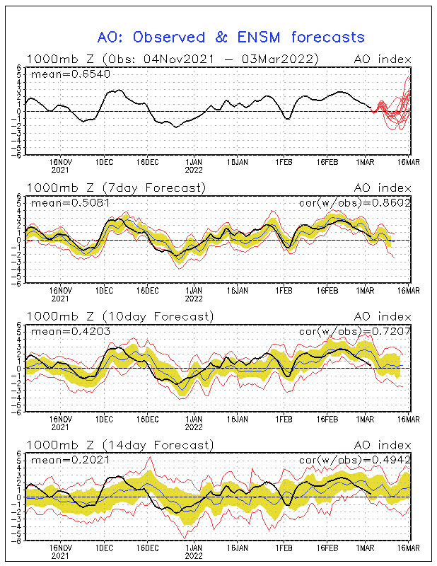
notice a peek into the postive area for when are expected thaw is and what follows it. of course this is not a direct corelation between the two but a negative ao is a cold singnal for the longer range this fits is nicely with the pna, nao values as well switching back to cold signals after a week 2 thaw in feb not to mention the euro weeklies are on board as well. so winter’s not over. but we all should welcome a thaw which couples nicely with my first round of exams.  i may cut back on posting that week we’ll see.

superbowl weekend forecast will snow fly to celebrate???

January 30, 2009

1. your saturday will see temps reach 32 ice areas and the mid to upper 30’s elsewhere with some afternoon sun some thawing may finally begin. morning fog and freezing fog is possibile with reduced visabilites.

2. sunday will see waa and some more melting of the ice watch out for falling ice and any branches that are down due to ice.  highs will reach 40 ice areas and the mid to upper 40’s elsewhere.  again my game forecast PIT 27, ARZ 21

3.  monday will see some light snow from a storm that looks quite a bit weeker today as a result the track has shifted east these two factors have reduced our snow chances to light snow with an inch or two east and a  inch or so toward lexington.  temps will fall into the 20’s late monday and nw winds will pick up.

latest map

usmap15


let’s look at the models the gfs is whacko for the sunday-wednesday timeframe the nam ,euro and cmc are close in line past monday.

nam mon eve

euro  tue am

north-america_ecmwf_1000-500_slpthk_96hr

now let’s jump ahead let’s not focus on our underacheiver over the east but the northern plains

nam tue

the same system a clipper is now located wednesday over the carolinas on the euro.

the gfs is to far south with the clipper and to amplified with the pattern

clipper tue-wed

usmap26

with this clipper snow ratios will be high but like msot clippers this one will be fast moving and mot have lots of moisture.


my feb forecast and 14 day outlook are both up!!!!

east east and away???

January 30, 2009

a quick storm update this afternoon

the has been a shift east in the expected track of the storm we’ve been watching for a few days

euro  00z

the new gfs continues the trend

what does this mean for us?

well if correct we would be in line for a much lighter of 1-3 with a sharp cutoff  west and north of frankfort.  i however think there will be a shift back to the west is it enough we’ll see but our chances for a 6+ snow have decreased today for the mon-tue event.

light wind to snowy times

January 29, 2009

1. for tonight and friday temps will stay in the mid to upper 20’s with scattered snow showers any snow will be under an inch i’m not impressed with radar returns tonight upstream. the main issue will be in the ice areas where a little bit more wind may lead to even more branches  and power lines falling. there still lots of folks in shelters and the dark keep them in your thoughts and prayers. on my drive to nky i was astonished at the widespread scope of ice damage at least i don’t have to drive in circles around the airport again anytime soon, bluegrass  of course is back open now.

2. saturday i think may stay partly to mostly cloudy after lows in the single digits to 10  highs will reach 25-30 in the ice areas and 30-35 outside those areas.

3. waa from the south will finally come sunday with full sunshine and highs pushing the low 40’s ice areas and mid to upper 40’s elsewhere more minor flooding issues may form as well with some melting to add to those warnings listed last night.

now on to the storm

euro

gz_pn_120_00001

jma


cmc

ukmet

gz_d5_pn_120_0000

00z gfs

this gfs run once again was way to week and east with the low with convective feedback problems

my path

usmap25

light blue 1-3 to gray “12”

storm recap and what’s coming

January 28, 2009

this site provided weather info tuesday to 1,121 of you that nearly doubled the numbers for any one day. for the month we’re at 6,936 visitors. welcome i wish it were under better circumstances.

1. storm recap

my house in versailles

http://www.youtube.com/watch?v=XAwB1sUTG7w

nws lmk site

g-town

lexington

kentucky.com

jessamine.co

snow and ice

house damage

– shelters are still open

– over 30,000 still without power in lex

– most schools closed

– state of emergency in madison.co, water issues for garrad and boyle counties.

we still have a few flood warnings out there

THE KENTUCKY RIVER NEAR RAVENNA…
  THE RED RIVER AT CLAY CITY…
  THE KENTUCKY RIVER AT HEIDELBERG, the south fork of the ky river and bath county

watch out for high water, turn around don’t drown!

2.  cold night tonight in areas with snow and ice pack lows around 10 there closer to 15-20 for everyone else.  slush will refreeze and black ice will form creating new slick spots any light wind could lead to a few more falling trees and lines.

3. thursday will see the sun come out highs will reach the upper 20’s over the snow areas and into the low 30’s elsewhere. maybe some minor thawing but a lot of ice will stay put. clouds will increase with snow showers moving in at night lows will be near 20.

4. these snow showers will leave an inch or so in some spots on friday but showers is the key word so  not everyone will see them. highs will only reach the upper 20’s. nw wind as well could be a concern for those iced surfaces.

5. saturday will start chilly with lows near 10 and some single digits highs may get to 30 with 32 possibile south.  sun will dominate

6. waa kicks in sunday ahead of the next system highs could get into the 40’s leading to melting. so the weekend doesn’t look that bad and hopefully everyone will  have power for the superbowl if not sooner PIT 27, ARZ 21 is my score.

7. a cold front moves through sunday night with unseasonabily warm air ahead of the front and another arctic cold airmass in behind it a storm should form in the central gulf and track northeast either up the apps on the east coast or somewhere in between.

12z euro

gz_pn_120_0000

gz_pn_144_0000

that’s a hvy snowstorm for us with near “b” condtions. you can figure what the b word is. again that’s only one model.

the new run of the gfs is not catching on to the orgainzation of the storm( convective feedback) and is to supressed as typical 00z gfs runs are.

but still a 2-6 snow this may be quite underdone as this is a further east track than most of the models and ensembles have and the 00z gfs has those convective feedback problems

look what happens by tue am quite an arcitic shock with strong winds in behind the system

yes that’s a accumlating snow for atlanta and flakes mixing in in florida!!

highs monday will be near 32 early falling throughout tuesday to the low 20’s.  i expect the precip to be all snow as thickness values and 850 mb temps fall off much quicker than surface temps. with snow cover single digits easy tuesday night with a shot at 0. wind chill adv and blowing snow may becoming issues.

my first snow map this may be to conserative on totals i took a track in between the two.

usmap14