Archive for November, 2010

Bad news east ky snow fans

November 30, 2010

Tuesday thoughts

1. This front is moving quicker than expected not only does it mess me up with my forecast for MI in the national wxchallenge but for you folks out east toward Pikeville and Ashland expecting a period of snow Wednesday Morning. Both the GFS and NAM have really backed off and if the 12z runs continue the trend I may have to remove any accumulation out of the forecast. Let’s hope an east ky snowdome isn’t coming back. This front will bring gusty winds to 40 mph and rainfall of around 1 inch.

2. Taking out flurries for Thu-Fri may get burned here but I’m just not seeing much.

3. speaking of not seeing much that was the 18z gfs run on our storm threat next week. The gfs is out to lunch and the ensemble spread gives it away the model is not doing well. That being said after a 00z euro run which gave bwg 6 inches of snow the next run implies light snow over the tenn valley middle next week and the cmc is flip-flop mode as well but the 12z run of the cmc and the jma show a good potential for accumulating snow tue-wed of next week. Sticking the course for now and feel confident in my thinking. The 12z jma out to 144 hours is a link to the side on this webpage and I’m in agreement with it.

– system A: tracks across the Ohio valley this weekend then deepens slightly off the coast of atlantic Canada

– system B: cuts underneath trough behind system A and moves across gulf coast states, band of accumulating snow to the north.

Forecast for the week

November 29, 2010

1. First to recap of discussion points over the weekend, if you closely you see two different categories for snow accumulation from Thu-Fri. One is for measurements taken right after snow fell of 1/2-1 inch the other is the following morning after the warm ground had actually caused snow melt at night and with measurements after the sun came up well even less was measured and thus the T to .5 inch measurements expect fro areas east of lex that actually got this much. Second our winter storm threat is still alive for the 7th. the CMC and its emsembles are still going with this along with a fair number of the gfs ensembles. The operational gfs doesn;t know what’s going on and the ECMWF still has the storm but a weird idea to make it a cut-off but on it’s 12z run still brings a streak of light snow into the region.  Another solution is for a track far enough south so the Tennessee valley gets a snowstorm around the 7th. So I will focus on this week and let the models sort out the mess. i still suspect a week low crosses the Ohio valley this weekend then deepens some causing the winter storm threat  system to move across the south with colder air to work with behind the first system.

2. Today we’ll see warm southerly flow and windy conditions with increasing clouds ahead of the next front. By tonight a band of rain and thunder should move from west t east through the day Tuesday. 1-2 inches of rain should fall regionwide. Highs Monday should reach the 50’s and stay there into Tuesday before falling temperatures from west to east during the day. Once again we have the issue of colder air catching up to the front as we have a secondary low along the front which should keep precipitation in longer for eastern Kentucky into Wednesday morning. With temperatures falling to near 30 a changeover to a period of snow with accumulations up to an inch is likely for areas such as Ashland and Pikeville. Most areas west of a Maysville to Jackson line will just see flurries Tuesday night.  

3. Wednesday much colder air will filter in behind the front with nw winds and overcast skies highs will stay in the 30’s regionwide with scattered snow showers and flurries some more light accums are possible in the far east.

4. Thursday and Friday should see a mix of clouds one needs to squint at the models to see a shortwave moving through this may lead to some flurries Thursday night and early Friday. Highs should be in the 40’s with lows in the 20’s.

5. After this the model uncertainty increases 10 fold. Remember above my critical analysis of the operational gfs well here is the 00z run actually getting in line with my thoughts. sill not trapping in the first low enough of Maine so the solution may be colder than shown.

Again that’s for dec 7. My confidence is increasing for a winter storm somewhere for the Ohio and Tenn valleys for early next week. Stay tuned.

14 day forecast now posted

November 27, 2010

check the link in the pages section.

sniffing a winter storm threat for days 7-10

November 27, 2010

The system coming in next weekend should be a week and occluded frontal boundary but this sets the stage for the storm after it in the 7-10 day period. This low thanks the to the -NAO should deepen a trough in the eastern US. A storm slamming the west coast should undercut this and develop a low pressure over texas by Tuesday December 7 and then move east with perhaps our best chance at a winter storm track across the south and up the east coast  this winter as some colder air will be already in place from the system next weekend. 

Right now the last 2 ECMWF runs have been showing a band of snow and ice tracking from the southern plains into the Missouri and Ohio Valleys.  The only free graphic I have below is for the 12z run.

This run is a little to cut-off but still has snow and ice moving into the commonwealth at this time.

the 18z gfs is starting to see something as well.

The ensembles or the average of many GFS runs is also seeing something.

This will be something to keep an eye on over the next few days, I’ll be back tomorrow with a forecast for the week.

December looking interesting for snow and cold fans

November 27, 2010

This early season snowfall on Turkey day may just be the start of several fun weeks of winter across the region. While the strength of the pacific jet still has me concerned and will lead to a very warm Jan-Feb for the region. December has more going for it.

– CFS still showing a cold december

– teleconnections

EPO

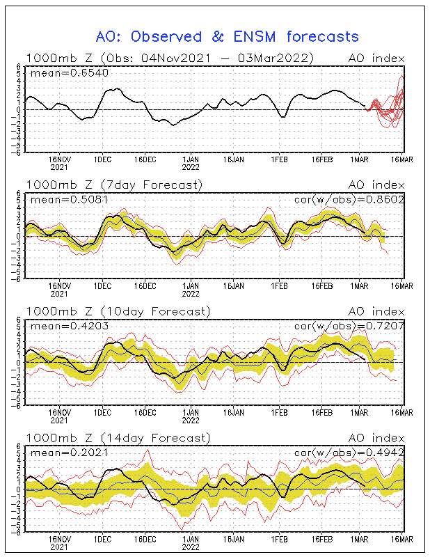
AO

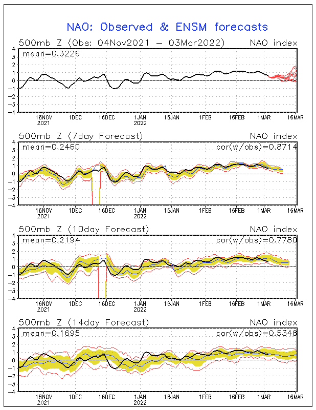
NAO

Overall all three of these telelconnections are very favorable for colder than normal temperatures well into December.

In addition a stratospheric warming period is beginning over the north pole. this usually consides with colder than normal temperatures about 7-10 days later in the east.

The pac jet will mean a back and forth tug of war between the pacific blowtorch and the very cold pattern that would result from these teleconnections. This week we’ll have a lakes cutter Monday and Tuesday with rain and thunder. Secondary low theory in full effect for Wednesday for far east ky where a period of snow and sleet is possible as the precip ends with flurries elsewhere. A second system cuts across the plains next weekend and upper Ohio valley, this low transfers to the east coast due to the – NAO another mainly rain to flurries event.

the third system may turn out to be a winter storm threat and be a rare storm that can follow track C in the winter outlook going from the southern Rockies and up the east coast, timing for this would be the second week of December. the storm next weekend should have some luck establishing a trough in the east with the next system undercutting it and taking this track. The GFS is to suppressed ( big shock there) but I’m thinking Friday’s 00z ECMWF run is on to something through day 10.

For this weekend skies should be mostly sunny with highs in the 40’s, some 50’s south on Sunday with lows in the 20’s and low 30’s. The next rain chance should hold off till Monday night.