Archive for the ‘Uncategorized’ Category

Things going well in NJ!

November 11, 2012

The weather links will continue to be active for those who wish to use them. All is well here in NJ both on a professional and personal level.

With no el-nino that winter forecast below needs some revision back in KY I’ll go near normal for temps and snowfall now.

Best wishes for a fun and safe winter season back in KY!

Last regular post and my winter forecast

July 10, 2012

This is my last regular post. I’m moving to NJ this weekend and start work Wednesday. I have enjoyed providing Kentucky with weather reports for the past several years. My life is taking me in another direction now and I’m really looking forward to my career in the NWS. Although when the weather picks up in KY I may drop a few lines from time to time. Also the links to other weather information will remain.

Where does the weather pattern go?

– Increase in showers and storms dents the drought and keeps temps near normal through the remainder of the summer.

– Drier and very warm for the fall. Another heat wave or two still likely.

– mild start to winter but many of you will like what I’m expecting for the second half of winter 2012-13.

What I feel confident in

– Transition to a moderate central basin el-nino for winter 2012-13. This provides some analogs for the fall and winter.

– Cold PDO has allowed the mean ridge to be further east this summer thus the heat. Cold PDO promotes a trough in the northwest. This would promote warm conditions across most of the US till it warms toward neutral.

Models

– I’ve seen some the ECMWF seasonal model though have limited access. However let’s look at the CFS.

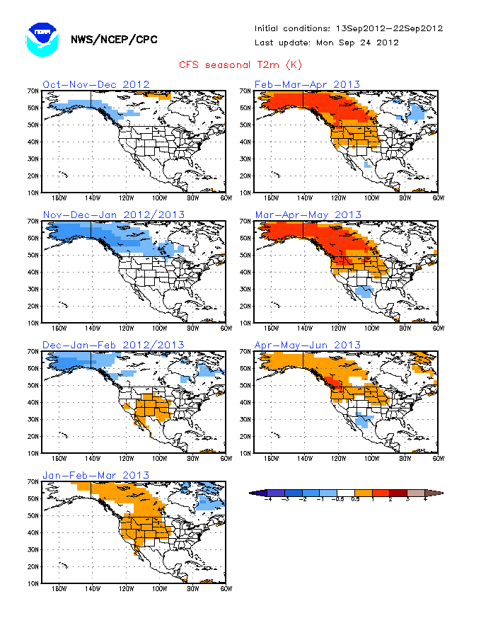
Version 1 above, Version 2 below

http://www.cpc.ncep.noaa.gov/products/CFSv2/htmls/usT2me3Sea.html

Version 2 shows a large region of above normal temperatures over the plains through the fall then over the northern plains for the winter. Precipitation patterns follow a typical el-nino. I think version 2 is to strong with the el-nino. Version 1 looks to cool for a lot of the forecast.

ENSO analogs several of them not weighted as much due to the PDO. If the PDO were warm I would be on board with my initial thinking for a blockbuster winter. I don’t think everything will come in line. Though the second half should make up for last winter with near to above snow overall for winter 2012-13.

Here is a list of moderate el-ninos following a la-nina or double la-nina

51-52, 76-77, 86-87, 02-03, 06-07, 09-10.

The 1976-77 bold should catch your eye that winter featured brutal cold and record snows.

However what was the PDO like in those years?

51-52 and 06-07 had cold PDO’s. The others all had warm PDO’s. 51-52 had the look of a la-nina winter warm and wet with the cold in the west. 06-07 started warm then turned cold. the other three with warm PDO’s were all cold and snowy for our region.

Also what about the AO and stratospheric warming? – Those were two factors which were hostle to any sustained cold and snow last winter. These are players which will be better known as winter gets closer.

month by month breakdown

August 1 degree above normal, stormy with above rainfall, some denting to the drought

September 3 degrees above normal, drier

October 3 degrees above normal, continued dry

November 3 degrees above normal, continued dry

December 2 degrees above  normal, quiet, little snow

January 2013- 2 degrees below normal , snowfall back to average,

February 2013- 3 degrees below normal, above normal snow

Winter starts quiet and warm Then flip in the first half of Jan to a much colder, stormier and snowier pattern. Snowstorm threats likely for the second half of the winter.

Snow totals 2012-13 winter

Lexington-18 in ( 2 in above normal)

Bowling Green 12 in ( 2 in above normal)

daily rain chances south, widespread storms later this week for all

July 9, 2012

Well the front stalls across TN leaving southern KY as having the best chance to see showers and storms through Wednesday. The front weakens into several disturbances one of those should push into the region for Thursday through Saturday and lead to several rounds of showers and storms with 1-3 inches of rain for the region on average. lows in the 60’s, highs in the 80’s.

Where does the front stall?

July 6, 2012

1. Saturday will be sunny with highs from 100-105 degrees. Looking at the impressive ridge and the 850 mb temps, many of us easily top 100. Heat index values will run from 105-110 thus excessive heat warnings and advisories are in effect. Take extra precautions from the heat.

2. Sunday a front moves into the Ohio Valley. Highs will soar into the 90’s before any cap can be busted late in the day with the development of scattered storms. instability should increase and with steep lapse rates storms may contain damaging winds and small hail. Storms may also train over the regions leading to heavy rains.

3. This front slowly sags south Monday and Tuesday with the best chances across southern KY. This front may move a little further south for the rest of the week but given this is summer I don’t expect that to happen. Instead the front should wash out across the TN valley and give at least southern portions of the region shower and storm chances through the end of next week. lows will be in the 60’s with highs in the 80’s. A optimistic view on rain next week is that a wave or two of low pressure may ride along the front enhancing rain chances, we’ll see.

July- Heat wave breaks mid-month to more of a normal pattern

July 1, 2012

Short term for Sunday night 7/1

– A severe thunderstorm watch has been issued for the bluegrass and I-71 regions. I could see a few scattered storms with gusty winds this evening for the watch area. Will be watching.

Long range forecast for July.  June actually had normal temperatures at Lexington for the month as a whole. I expect July to be around 5 degrees above normal for the first half then near normal the second half of the month.

I don’t see the heat wave breaking till at least July 10th. Overall drier than normal through mid-month then more fronts may allow for normal precipitation the second half of the month. I also expect a very hot period for late August into September.  The ridge gradually retreats west this week into the southern plains and Rockies. Getting this even a bit further west into the PAC NW is key and would result in a cooler pattern.

1. Over the next 10 days highs should be in the 90’s each day with a few hit and miss storms in the late afternoon and early evening. Where conditions are drier say BG a few more days near 100 are possible. The storms may have the ability gusty winds may result from any storm this week. We’ll have to watch for disturbances as well which may allow storms to organize. overall I’m not that optimistic a considerable of Convective inhibition also known as a CAP will be present in the mid-levels of the atmosphere making it hard to get storms without a trigger. Coverage and chances should be no more than 20-30% each day. Overnight lows will be in the 70’s as well this next week.