I’ll go over the new years frontal system with a new post by noon or so on Thursday. In the meantime I see some conflicting signals in the long range for days 6-15.
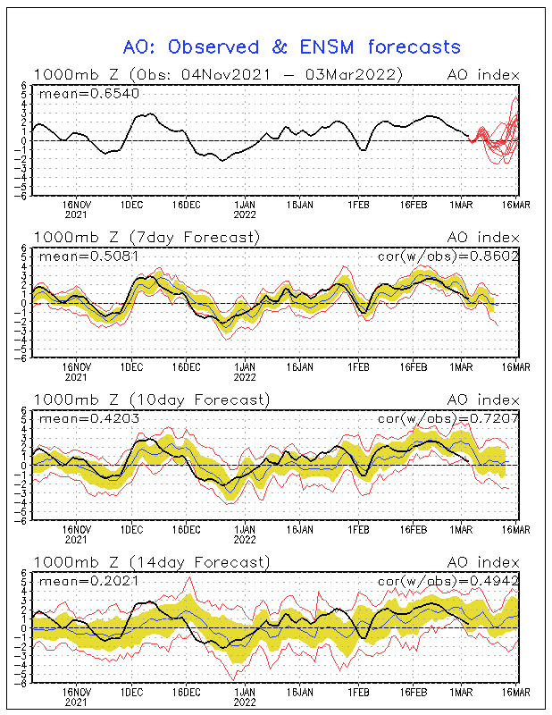
the AO may tank once again

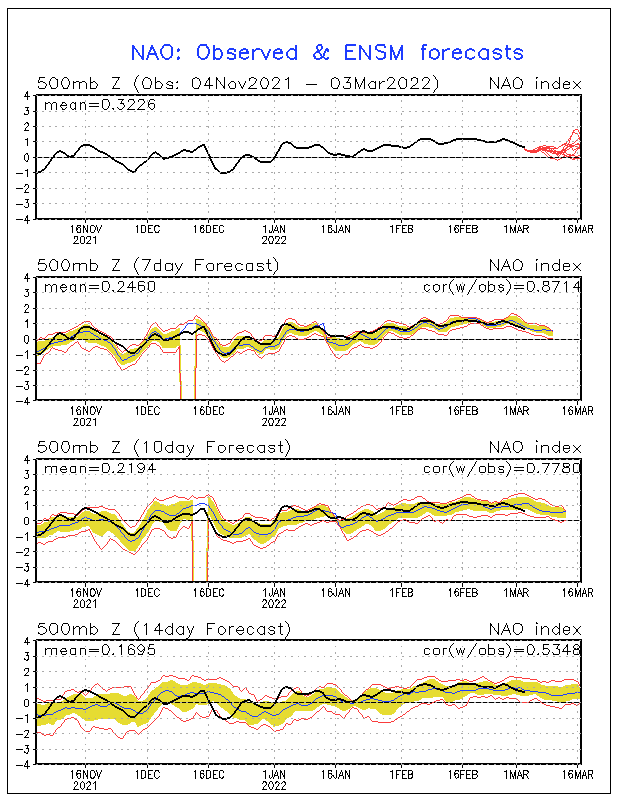
taking with it the NAO

GFS temps days 11-15

the ECMWF still has more of a normal to slightly below normal look at day 10 with some pacific flow getting into the mix

This will be something to track over the next few days. We should also have a system of interest in terms of snow chances toward the middle and end of next week. The ECMWF holds the energy back to much while the GFS is to suppressed with the pattern, nothing new there 7 days in advance of a system. Right now if I had to guess I’d say a low pressure forms over texas Thursday of next week and cuts west of the apps before transferring to a secondary by next weekend meaning a sloppy mix around here. I’ll leave this be for a few days to focus on the new year’s front which is one where the severe threat can’t be ruled out yet.
I’ll throw in one more bonus thought that another stratospheric warming event may be coming after day 10 which could in displacement of the polar vortex. here is the gfs on day 16. let’s not jump on this to much as the la-nina is also strong.

here is a good read from Kirk Mellish in Atlanta wsbradio
December has been dominated by a trough in the Gulf of Alaska, a strong west-based -NAO, and a trough in the southeast US. This pattern has led to the axis of colder than normal temperatures form the Plains into the southeast US, with the strongest cold anomalies being located over the Ohio Valley to the southeast. The Arctic Oscillation (AO) and North Atlantic Oscillation are behind the cold winter of last year and the cold start to this one. They are tied to the Atlantic Ocean temperature pattern and to a lesser degree Pacific Ocean temperatures, both of which undergo multidecadal cycles (30-70 years). The favored states of the AO and NAO are tied to the phases of these long term oscillations. The long term ocean cycles are natural changes and linked to variations in the meandering thermohaline circulation likely tied to solar influences. They behave predictably as an average condition over long-time frames (decade or more), but unpredictably over shorter time frames from months to years.
Clearly the wild card of this winter (the AO/NAO), which is only forecastable specifically on a daily to two-week in advance time frame, has been the dominant factor for the first month of winter. The negative trend of the Arctic and North Atlantic oscillations with the attendant Greenland blocking pattern of the jet stream has thus far overwhelmed any Pacific Ocean La Nina influence. This was anticipated in the long-range call for winter, BUT NOT TO THIS EXTREME. The fast, early start to winter and fade down the stretch forecast has started out well in terms of the pattern but not the numbers. Obviously it remains to be seen if the fade for the core of winter comes or not.
Preliminary speculation is that Previous year’s high latitude volcanic eruptions (Alaska and Siberia 1-3 years ago) combined with the historic low sun spot cycle are working together to aid the negative NAO causing the abnormal snow and cold in the South and East U.S. and Europe.
The tropical summer and fall weather patterns and ocean temperatures aided the historic hurricane season numbers, and likewise seem to have had more pull on the large-scale atmosphere than the La Nina in the Pacific. In addition the strength of the La Nina has been less than numerical and statistical equations predicted thanks to weakening from the Madden Julian Oscillation (MJO) in the equatorial Pacific.
This rare combination leading to the very cold December for much of the nation indicates there is no reason to believe there will be any lasting super warmth this winter. It also means that my forecast for milder weather to take over slowly but steadily in January and February over the Southeast states is in jeopardy. I think after about a period of 6-14 days of changeable weather with milder temperatures than what we have seen so far this winter, we will revert to a similar pattern to what we have seen in December. This means that mine as well as others forecasts of a warmer than normal mid to late winter may go by the wayside. While January gets its thaw, there is little to indicate widespread lasting warmth or any blowtorch warm-up beyond fleeting.
Cold will return to the East and South, but if La Nina has its way it will be closer to normal cold for January and February. So I am not totally abandoning the flip in the pattern previously expected yet, as it may simply be delayed but not denied. But pending new model output on the NAO and a review of analogs I may have to make that change.
The reason for not jumping the gun is two fold. One, the cold December itself helps to destroy part of its cause, by cooling the Atlantic Ocean and Caribbean Sea/Gulf of Mexico (positive AMO Atlantic Multidecadal Oscillation) which when warm in winter draws cold air down into it. Second, the hurricane analogs which suggested the cold December in the East and Southeast still show milder conditions for the January-February period in most of the East and South followed by Spring chill from DC northward. But at least the next 6-10 days or so will be much more moderate East of the MS River. After that there is a battle between the La Nina signal taking over and model forecasts of a SSW event at 10mb (sudden stratospheric warming above the North Pole) the first projects mild but the second argues for a return of polar air after the thaw.
The warming aloft this fall and early winter in northeast Canada and Hudson Bay is part of the very strong negative arctic oscillation pattern we have seen the last few years, in part related to the long solar minimum and high latitude volcanoes. The positive AO state is characterized by an anomalously strong polar vortex that traps cold air in high latitude and more zonal mid-latitude jet stream that allows maritime Pacific air to invade North America and Atlantic air to flood Europe often as far east as The Urals. In the negative mode, high pressure dominates the polar region and North Atlantic, shunting arctic air south in North America and Siberian air west to Western Europe. (see slide show)
A positive AO leads to increasing temperatures in the Northern Hemisphere continents with colder than normal air trapped in the arctic down to the northern parts of Canada and Hudson Bay.
As noted, the North Atlantic Oscillation, an important component of the overall arctic oscillation varies with the ocean temperature tripole in the Atlantic, known as the AMO or Atlantic Multidecadal Oscillation. When the Atlantic is in the warm positive AMO mode as is currently the case, the NAO and AO tend to be more negative.
When the AMO is positive with warm water in the North Atlantic and in the Tropical Atlantic, the NAO was mainly negative (1960s). When the North and Tropical Atlantic turned cold in the 1980s, the NAO was mainly positive. Note the AMO flipped positive (warm) in 1995 with a big dip in the NAO.
So far this late fall and early winter, the AO has been mainly negative and forecast by the model ensembles to remain so.
This unexpectedly strong -AO/NAO explains not only the brutal cold in Europe and Asia but also the amazing 11F negative anomalies in the southeastern United States. NOTE AMAZINGLY how even though we have replaced the strong El Nino with a strong La Nina, and the QBO (Quasi-biennial Osscilation) was EAST last winter but is WEST this winter yet the result so far has been virtually the same for the start of the Northern Hemisphere winter. It is even colder in the southeast US, in Alaska and India. In the southern Hemisphere note the cold December to date in Australia and much of South America (the start of their summer). Summer snow even fell in southeast Australia.
These run contrary to what has happened in the past and is verification of the concern expressed in the winter forecast release at the end of October that finding solid analog years was being made difficult by unprecedented ocean-atmosphere-sun alignments.
____
back to me
For now i stil like the normal approach for the remainder of winter which is considerbaily cooler then the 3-5*F above normal temperatures predicited for this time period. Still folks a normal Jan-feb after the record Dec is rather cold and snowy. but if there’s still further adjustment it may be colder.

