Archive for December, 2008

short term: happy new year!!!! (post 1 of 2)

December 31, 2008

1. thursday will still see a chilly start in the mid to upper 10’s, chilly with 20’s for any new years stuff going on. i won round 2 with the mos to even us at 1 round a piece my 32 for a late pm was spot on the mos had 36.  we’ll do round 3 tommorow my forecast 39-42 a 20-25 *F warmup with a bit of southerly flow fits nicely with raw data as well the mos has 45-47.  fair skies tommorow.

2. still a burst of lgt snow early friday the nam efforts for reviving this sytem are not working out well maybe some coatings highs in the mid to upper 30’s.

3.  waa picks up for the weekend with scattered rain showers 40’s for highs sat and upper 30’s sun as a cool front pushes through.

4. i’m glad to see vandy win a the music city bowl but at the same chearing against the ville now, back to sports on tv, plenty of it today!

5. i’ll see you next year about 12:30 am or so with post 2 of 2.

sham wow and hamburger sliders

December 31, 2008

1.  i lost to the mos in round 1 with today’s temps round 2 is tommorow i’m thinking 32 for frankfort and the mos has 36 (late pm temps).  the clipper should move through tonight bringing gusty nw winds and some flakes early wed.

2. this system for thursday and friday looks week even weeker today as the models continuing there trend for a drier system due to it’s quick movement and that a new wrinkle is on it’s heals. a period of lgt snow is likely friday am with some coatings. highs both days should be in the mid 30’s. there could be a slick spot or two.

nam radar fri am

3. another week system, our wrinkle will move east for late sat into sun with some rain showers there should be enough waa for low 40’s sat and upper 30’s sat for highs and a all rain event with only lgt amounts.

4. some arctic air should come behind this system for our major system which has been highlighted for a few days occuring around jan 6.  highs should be in the mid 30’s with fair skies monday.

storm update  jan 6-9

– this could be a wave train instead of one low pressure

– models have trended colder today both gfs and euro


euro jan 6

gz_pn_168_00001

euro jan 7

 gz_pn_192_00002

this shows a brief mix changing to snow tuesday with several inches.

gfs jan 6

to far west BUT  that is good thing remember from earlier where i said the gfs trends to far east, both of these are much better than lake cutters in terms of snow which these models had 48 hrs ago. 

here’s a familar pitch  from billy mays selling hamburger sliders or the sham-wow guy!

but wait there’s more we’ll add in a second wave of low pressure  for no addtional charge, at least the gfs does.

this on jan 7 when i will be taking the gre which means a big snow is likely when i’m inside for the day!!

then sham-wow!

 this is showing the potential for a 6+ snow for the 6th-9th.

but as billy mays and the sham-wow guy always say call within the next 10 minutes and the deal is even better!

gfs 00z  jan 9

gfs 00z jan 12

jan 16

notice the pattern brings in several clippers and lots of cold not to many days near freezing past jan 5.

i hope you have seen one of those commericals if not just know a snowy and cold pattern is coming!!!

update on friday’s snow chance and a bigger storm

December 29, 2008

1. first things first  i don’t see how we hit 60 tommorow like some forecasts are indicating

gfs temps

high of 10*c= 50* F we don’t reach that in lex and maybe a little over that south.

let’s look at the mos highs for the record the raw numbers are what should be used in my view there is no purpose for the mos numbers, lots of issues with them.

lex-54

som-59 that’s close and oh yes corresponds nicely with this

from the nws

BROAD SW FLOW AHEAD OF THE
SYSTEM WILL ALLOW TEMPS TO TOP OUT SLIGHTLY WARMER THAN TODAY WITH
HIGHS TOPPING OUT INT HE LOWER 50S ACROSS THE NORTH AND UPPER 50S TO
NEAR 60 ACROSS THE SOUTH.  FEEL THAT BEST SHOT OF HITTING 60 WILL BE
DOWN IN OUR COUNTIES ALONG THE KY/TN BORDER.


they used the mos numbers, i’ll use raw we’ll see who is right.

50(me) lex vs 56 mos/nws

54 som vs 60 mos/nws

2. no change for wed as well highs near 32 and some flakes with a nw wind.

3. thrusday night and friday we see light snow move in no mix based on all the data it’s cold enough for snow everywhere. the question lately will qpf be enough for accumlating snow.

nam qpf

bone dry just flurries

gfs qpf

an inch or two from lex east.

i’m still thinking 1-3 out of this as we’re experiencing normal issues with the models.

more waffling with our big storm for jan 6-9

00z gfs jan 6 don’t look!

18z gfs look and smile, jan 9

the euro tracks a low right overhead of us.  more waffling to come.

new years week forecast

December 29, 2008

1. haven’t had a shout out to my sports teams in a while since the phills won the world series!

the uk football cats who managed to make it to a bowl game by default (6-6) mark, still 3 straight bowl years! they head to memphis to take on east carolina friday, a tough c-usa team.  go cats!

http://www.libertybowl.org/

weather for memphis

temps near 35 snow flurries nw wind near 10 mph.

the b-ball cats our on a nice winning streak now 10-3, big one this sunday against the hated cards from louisville.

good

bad or ugly your pick

my eagles somehow made the playoffs after a tie to your bungals of all things, thanks to help from oakland, houston and a great game against those hated cowboys!!!!

2. let’s get down to it! monday and tuesday look mostly sunny with mid to upper 40’s for highs and light winds, a nice change.

3.  a week clipper looks a little stronger for tuesday night and new years eve highs wednesday will reach freezing with a strong nw wind. scattered snow showers and flurries will get us back in the snow mood.

4.  a little southerly flow ahead of the next arctic front will allow highs to rebound into the upper 30’s thu however low pressure forms in texas and coupled with this boundry brings in some snow thursday night with lows in the upper 20’s. notice no mix all of the models for the most part are in agreement for all snow regionwide with perhaps the far se seeing a brief mix.

thu night gfs thickness ( 540 is rn/sw line in this case)

my thu night map

us-map22

5. this system tracks up the east coast for friday into saturday for us i don’t see this now as more than a 1-3 inch type snow as this system will be a quick mover and not have a ton of mositure, the 12z gfs had way to much qpf and has backed off to not enough qpf now. the good news is we look cold enough for all snow but i’m not buying that gfs run or forecasts calling for more than .5 qpf.  of course this can all change.  1-3 is better than nothing, don’t have panic attack if this storm doesn’t satisfy your every dream for snow, that storm  is coming up in a minute.  highs should be near 30 both days with any snow ending by sunrise saturday.

us-map33

now to that long range storm that we can have panic attacks and wild emotion swings on every run since i think this storm CAN BE A WINTER DEFINING STORM. the timing is from jan 5-8, the gfs and euro runs will flip and flop back and forth on the track and timing of the storm.  the gfs will be to east and the euro to west.

the big picture for now is most important, big storm with enough snow possbile to satisfy our dreams or another big disapointment. the stuff needed for a big storm lots of juice, upper level energy and a strong temp gradient will be there.

let’s look at some of the possibilites

gfs 00z jan 6

it starts things out as an ice storm then rain changing to several inches of snow

gfs 18z from dec 27 on jan 8


this would be a 6-10 inch snow.

euro 12z from dec 27 on jan 7

gz_pn_240_00002

the low is indiana another rain to snow BUT the euro is up to it’s usual tricks on this run digging to much of a west coast trough forcing the track to far west. again with qpf near or over 1 inch liquid this could be a very big storm.

an arcitc outbreak is set for after this storm into the middle of jan.

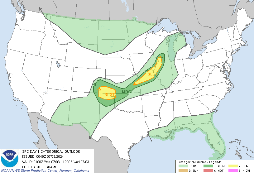
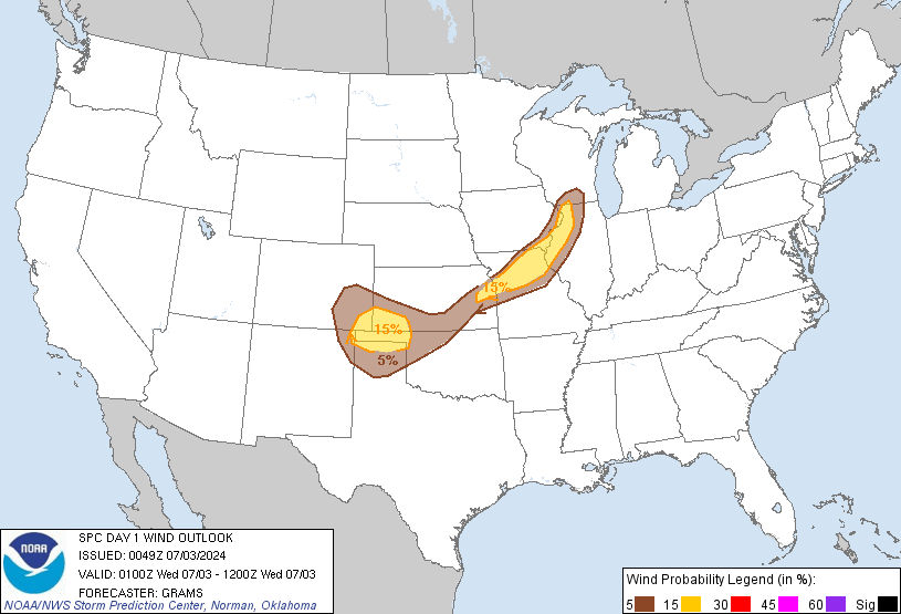
severe weather update 9:00 pm ( for areas west of 1-75)

December 27, 2008

1. instabilty and unseasonable warmth has lead to the delevopment of a squall line and even some tornadoes to our west, that was my fear a few days ago for our area but the timing of the front slowed a bit leading to a conclusion that this line would quickly weeken.

2. the storms have been slower to weeken than what i thought and the spc thought as well. the tornado threat is gone but there still numerous warnings  along a healthy squall line moving west to east across the state with winds to 60 mph and wind damage.

3. if you’re a spotter, spotter activation may be requested.

4. i’ve decided to go into severe weather  mode more as a test for later on but there is a chance these storms could still be near severe levels as they get to the lex area and west of I-75. these storms should weeken with the loss of the sun to create instabilty.

spc outlook

no word on a new watch, i’ll be checking the md’s for that.

the storms are moving east at 40 mph

they will reach

louisville 11:15 pm

shelbyville 12:00 am

campelsville 12:15 am

frankfort 12:35 am

lexington/ danville 1am